
Izu-bonin-Marianas
The Izu-Bonin-Mariana (IBM) arc extends 2800 km from Guam to Toykyo, and includes the Izu, Bonin, and Mariana Islands (Fig. 1). Here, the Pacific Plate is subducting westward beneath the Philippine Sea Plate at an oblique angle. This represents subduction of some of the oldest oceanic lithosphere in the world, ranging in age from Early Cretaceous in the north to Mid-Jurassic in the south (Jarrard, 1986; Mueller et al., 1997; Stern et al., 2003). We seek to understand the structural and magmatic evolution of the IBM arc and the Mariana back-arc, and the links with hydrothermal systems.

Figure 1. The tectonic setting of the Izu-Bonin-Mariana subduction zone, overlain on regional bathymetry (GMRT v.3.2; Ryan et al., 2009). Ages of oceanic crust are from Bouysse et al. (2010) and references therein. Seafloor fractures are from Matthews et al. (2011) and Wessel et al. (2015). Subduction rates are relative to the Philippine Sea Plate, from deMets et al. (2010). MP = Mariana Microplate. Figure from Anderson et al. (2017).
Our work (in partnership with NOAA-PMEL) has revealed substantial tectonic complexities in the southern and central Mariana back-arc, resulting in diverse morpho-tectonic fabrics and styles of volcanism (Anderson et al., 2017). We have identified four morphologically distinct segment types associated with variations in magma supply, proximity to the volcanic arc, and influence of cross-arc structures (Fig. 2). Recent cruises have resulted in discoveries of new hydrothermal vent sites along all segment types (Baker et al., 2017), and the deepest historical volcanic eruption ever documented (Chadwick et al., 2018).

Figure 2. Multibeam bathymetry of the central Mariana back-arc collected during the “Hydrothermal Hunt” research cruise (FK151121) showing diverse seafloor morphologies. Hydrothermal vent sites are indicated by yellow stars (data from Anderson et al., 2016).
Ongoing work: Our work in this area continues to focuse on understanding the structural-volcanic evolution of the subduction, extending our area of investigation to the north and to encompass the arc, and the development of Mineral Prospectivity Maps to identify sites with high potential to host inactive hydrothermal vent sites.
New Hebrides (Vanuatu – solomon islands)
The New Hebrides arc originally formed part of the continuous Melanesian Arc along the Vitiaz Trench where the Pacific Plate was subducted beneath the Indo-Australian Plate (Fig. 3; Hall, 2002). In the Late Miocene, a collision with the Ontong Java Plateau induced a reversal of subduction polarity, and the Indo-Australian Plate began to subduct eastwards beneath the Pacific Plate. This was accompanied by slab rollback and the opening of the North Fiji Basin (Auzende et al., 1995). A second phase of back-arc extension beginning at ~6.5 Ma resulted in the formation of the Coriolis Troughs (CT) in the south and the Jean Charcot Troughs (JCT) in the north (Monjaret et al., 1991; Pelletier et al., 1998). These are some of the youngest back-arc rifts in the world. Our work has focused on understanding the evolution of this subduction zone and the effects of tectonic complexities, such as ridge collisions, asymmetric hinge rollback, and pre-existing structures, on volcanism and hyrothermal venting in the back-arc (in partnership with Neptune Minerals., Inc., GEOMAR, Univ. Erlangen, and Jacobs Univ.).
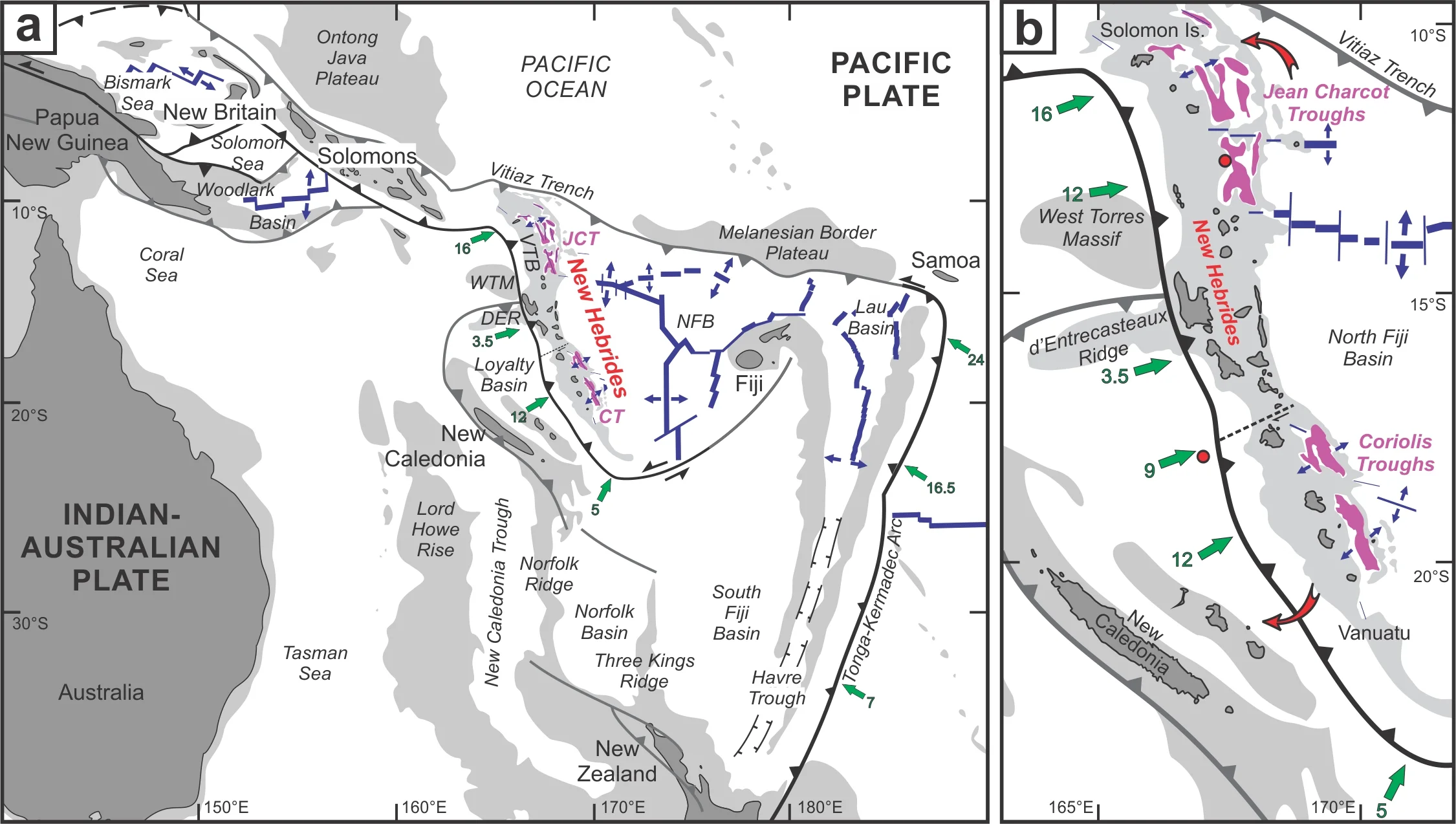
Figure 3. Geographic location and tectonic features of: (a) the southwest Pacific and, (b) the New Hebrides (Vanuatu and southern Solomon Islands). Light grey areas represent the 2000 m isobaths, green arrows indicate convergence directions and rates (cm/yr), blue lines represent spreading centers, and the New Hebrides back-arc rifts (Coriolis Troughs and Jean Charcot Troughs) are indicated in purple. CT = Coriolis Troughs, DER = d’Entrecasteaux Ridge, JCT = Jean Charcot Troughs, WTM = West Torres Massif. Figure from Anderson et al. (2016), modified from Hall (2002).
The CT are characterized by narrow (25–45 km wide), deep (> 3 km below sea level) grabens that are in close proximity (~50 km) to the arc front (Fig. 4). Here, we have explored the tectonic mechanisms for focusing voluminous basaltic eruptions in otherwise magma-deficient back-arc rifts, forming the Nifonea shield volcano (Anderson et al., 2016). This work has demonstrated how subduction zone collisions with buoyant oceanic plateaus can influence upper plate stresses, forming structural conduits that are exploited by basaltic magmas. We have explored how this style of effusive volcanism influences hydrothermal venting in the Nifonea caldera (Anderson et al., 2016; Schmidt et al., 2017; Keith et al., Submitted).

Figure 4. Multibeam bathymetry of the Coriolis Troughs (CT), New Hebrides back-arc, Vanuatu, overlain on global marine altimetry data (Sandwell et al., 2014). The Nifonea shield volcano is located in the northernmost Vate Trough. Hydrothermal venting is indicated by yellow stars (after Beaulieu et al., 2013). Figure from Anderson et al. (2016).
In contrast to the CT, the JCT are characterized by irregular horst-and-graben structures with variable orientations extending up to ~120 km from the arc front (Fig. 5). Here, we have documented the role of rifting along pre-existing structures in the formation of the complex seafloor morphologies, which have been further modified by collisions with buoyant oceanic plateaus (Anderson, 2018). We have also demonstrated how rifting on a structurally-complex upper plate can result in zones of enhanced crustal permeability that are exploited by magmatic-hydrothermal systems. The style of extension in the JCT provides a first-order control on the style of volcanism, resulting in fissure-eruptions in arc-proximal settings. Explosive mafic volcanism has not been widely described on the modern seafloor. In partnership with Neptune Minerals, Inc., we have investigated the actively-forming Tinakula massive sulfide deposit, which is the first modern analog of an SMS deposit hosted by bimodal-mafic volcaniclastic rocks (Anderson et al., In Rev.). Shallow drilling has provided a unique view into the third dimension of the system, allowing us to investigate how hydrothermal fluids can become focused in permeable volcanic successions, highlighting the important role of anhydrite, which is typically not preserved in the geologic record.

Figure 5. Global satellite altimetry of the Jean Charcot Troughs (JCT) from Sandwell et al. (2014), with back-arc troughs indicated by the grey hatched pattern. The location of the Tinakula SMS deposit and other sites of hydrothermal venting are indicated by yellow stars (after Beaulieu, 2013). Figure from Anderson et al. (In Rev.).
Ongoing work: We continue to investigate the regional tectonics of the JCT, with an emphasis on understanding the role of the collision with the West Torres Massif on arc volcanism and back-arc structures. We continue to work in partnership with Neptune Minerals, Inc., to study newly-discovered deposits and their relationships with the tectonic setting in order to understand how tectonic complexities, such as ridge collisions, influence the metallogenic potential of the subduction zone.
Tonga-kermadec arc – lau back-arc basin
The Tonga-Kermadec subduction zone is associated with the fastest subduction rates in the world (Bevis et al., 1995). This region has been key to understanding geodynamic processes since the theory of Plate Tectonics was established, and the Lau Basin is where the idea of back-arc extension was first developed (Karig, 1970). Since then, numerous geochemical, geophysical, and geodynamic studies have focused on understanding the complex tectonic evolution of this area. The Lau back-arc basin separates the inactive Lau Ridge from teh active Tofua Arc (Fig. 6). The basin is wider in the north, with southward-propagating extension over the last 4 Ma (Taylor, 1996). Subduction of chain of seamounts that form the Louisville Ridge has influenced the structures in the forearc, arc, and back-arc regions (e.g., Ballance et al., 1989; Funnell et al., 2014). There are numerous spreading centers in the back-arc that define the boundaries of several microplates (e.g., Zellmer and Taylor, 2001; Sleeper and Martinez, 2016). Interactions between these microplates is shedding light on tectonic processes that have been active since the Archean.

Figure 6. Compilation of multibeam bathymetry (GMRT v.3.2; Ryan et al., 2009) overlain on global marine altimetry data (Sandwell et al., 2014) of the Tonga-Kermadec arc and the Lau back-arc basin. Spreading centers are shown by red lines, hydrothermal vent sites are shown by yellow stars (after Beaulieu et al., 2013), spreading rates and directions are indicated by green arrows (after Zellmer et al., 2000), and subduction rates and directions are indicated by white arrows. CLSC = Central Lau Spreading Center, ELSC = East Lau Spreading Center , FRSC = Fonulei Rift and Spreading Center, FSC = Futuna Spreading Center, ILSC = Intermediate Lau Spreading Ridge, LETZ = Lau Extensional Transform Zone, MTJ = Mangatolu Triple Junction, NELSC = Northeast Lau Spreading Center, NWLSC = Northwest Lau Spreading Center, PR = Peggy Ridge; RR = Rochambeau Rifts; VFR = Valu Fa Ridge.
Ongoing work: The Tonga-Kermadec subduction zone the most tectonically- and volcanically-active places on Earth, providing an ideal natural laboratory for studying the relationships between tectonics, seafloor structures, volcanism, and hydrothermal venting. We have initiated a new program of research in the NE Lau Basin to investigate the structural evolution of this complex area and the influence on the siting of hydrothermal vents (partnership with Univ. Erlangen, Univ. Hawai’i, Univ. Ottawa, and GEOMAR). We are also initiating new research into the giant Niuatahi volcano in order to understand the development of caldera structures and the influence on venting (partnership with Univ. Hawaii, MUN). We continue to partner with Neptune Minerals, Inc., to investigate newly-discovered deposits in order to unravel the local geologic controls on venting. Finally, we are working in partnership with the Univ. of Ottawa and GEOMAR to develop the first-ever regional geological maps of the seafloor (modern-ancient crust project of Metal Oceans). This work is shedding new light on the the influence of geodynamics on the metallogenic potential of arc-back-arc systems, and the emergence of microplate boundaries in both modern and ancient terranes.
References
Anderson, M.O., 2018, Relationships between tectonics, volcanism, and hydrothermal venting in the New Hebrides and Mariana back-arc basins, western Pacific: Ph.D. thesis, Ottawa, Canada, University of Ottawa, 1030 p.
Anderson, M.O., Hannington, M.D., McConachy, T.F., Jamieson, J.W., Anders, M.*, Wienkenjohann, H.*, Strauss, H.A., Hansteen, T., and Petersen, S. Mineralization and alteration of a modern seafloor massive sulfide deposit hosted in primary volcaniclastic rocks. Economic Geology (In Revision) [open access].
Anderson, M.O., Hannington, M.D., Haase, K.M., Schwarz-Schampera, U., Augustin, N., McConachy, T.F., and Allen, K., 2016. Tectonic focusing of voluminous basaltic eruptions in magma-deficient backarc rifts. Earth and Planetary Science Letters 440, 43–55, doi:10.1016/j.epsl.2016.02.002.
Anderson, M.O., Chadwick, W.W, Hannington, M.D., Merle, S.G., Resing, J.A., Baker, E.T., Butterfield, D.A., Walker, S.L., and Augustin, N., 2017. Geological interpretation of volcanism and segmentation of the Mariana back-arc spreading center between 12.7°N and 18.3°N. Geochemistry, Geophysics, Geosystems 18, 2240–2274, doi: 10.1002/2017GC006813 [open access].
Auzende, J., Pelletier, B., and Eissen, J., 1995. The North Fiji basin: geology structure, and geodynamic evolution. In: Taylor, B. (Ed.), Back-arc Basins: Tectonics and Magmatism. Plenum, New York, pp. 139–175.
Baker, E.T., Walker, S.L, Resing, J.A., Chadwick, W.W. Jr., Merle, S.G., Anderson, M.O., Butterfield, D.A., Buck, N.J., and Michael, S., 2017. The effect of arc proximity on hydrothermal activity along spreading centers: New evidence from the Mariana back-arc (12.7°–18.3°N). Geochemistry, Geophysics, Geosystems 18, doi: 10.1002/2017-GC007234 [open access].
Ballance, P.F., Scholl, D.W., Vallier, T.L., Stevenson, A.J., Ryan, H., and Herzer, R.H., 1989. Subduction of a Late Cretaceous seamount of the Louisville Ridge at teh Tonga Trench: A model of normal and accelerated tectonic erosion.
Beaulieu, S.E., 2013. InterRidge Global Database of Active Submarine Hydrothermal Vent Fields: prepared for InterRidge, Version 2.3 (http://vents-data.interridge.org).
Bevis, M., et al., 1995. Geodetic observations of very rapid convergence and back-arc extension at the Tonga arc, Nature 374, 249–251.
Bouysse, P., et al., 2010. Geological Map of the World at 1:25 M, 3rd ed., 2 sheets, CGMW, UNESCO, Paris.
Chadwick, W.W. Jr., Merle, S.G., Baker, E.T., Walker, S.L., Resing, J.A., Butterfield, D.A., Baumberger, T., Bobbitt, A.M., Anderson, M.O., Shore, P., and Wiens, D.A., 2018. A recent volcanic eruption discovered on the central Mariana back-arc spreading center. Frontiers in Earth Science 6, 1–16, doi: 10.3389/feart.2018.00172 [open access].
DeMets, C., R. G. Gordon, D. F. Argus, and S. Stein, 1994. Effect of recent revisions to the geomagnetic reversal time scale on estimate of current plate motions, Geophysical Research Letters 21(20), 2191–2194, doi: 10.1029/94GL02118.
Funnell, M.K., Peirce, C., Stratford, W.R., Paulatto, M., Watts, A.B., and Grevemeyer, I., 2014. Structure and deformation of the Kermadec forearc in response to subduction of the Pacific oceanic plate, Geophysical Journal Interanational 199, 1286–1302.
Hall, R., 2002. Cenozoic geological and plate tectonic evolution of SE Asia and the SE Pacific – computer-based reconstructions, model and animations, Journal of Asian Earth Sciences 20, 353–431.
Jarrard, R. D., 1986. Relations among subduction parameters, Reviews of Geophycis 24(2), 217–284, doi: 10.1029/RG024i002p00217.
Karig, 1970. Ridges and basins of the Tonga-Kermadec island arc system, Journal of Geophysical Research 75, 239–254, doi: 10.1029/JB075i002p00239.
Keith, M., Haase, K.M., Hackel, F., Schwarz-Schampera, U., Anderson, M.O., Hannington, M.D., McConachy, T.F., and Strauss, H.A. Effects of magma degassing and fluid boiling on submarine back-arc hydrothermal systems, Nifonea volcano, New Hebrides back-arc. Chemical Geology (Submitted).
Matthews, K. J., R. D. Miller, P. Wessel, and J. M. Whittaker, 2011. The tectonic fabric of the ocean basins, Journal of Geophysical Research 116, B12109, doi: 10.1029/2011JB008413.
Monjaret, M.C., Bellon, H., and Maillet, P., 1991. Magmatism of the troughs behind the New Hebrides island arc (RV Jean Charcot SEAPSO 2 cruise): K–Ar geochronology and petrology. Journal of Volcanology and Geothermal Research 46, 265–280. doi: 10.1016/0377-0273(91)90088-H.
Mueller, R. D., W. R. Roest, J. Y. Royer, L. M. Gahagan, and J. G. Sclater, 1997. Digital isochrons of the world’s ocean floor, Journal of Geophysical Research 102(B2), 3211–3214, doi: 10.1029/96JB01781.
Pelletier, B., Calmant, S., and Pillet, R., 1998. Current tectonics of the Tonga–New Hebrides region. Earth and Planetary Science Letters 164, 263–276.
Ryan, W. B. F., et al., 2009. Global multi-resolution topography synthesis, Geochemistry, Geophysics, Geosystems 10, Q03014, doi: 10.1029/2008GC002332.
Sandwell, D.T., et al., 2014. New global marine gravity model from CryoSat-2 and Jason-1 reveals buried tectonic structure, Science 346, p. 65–67.
Schmidt, K., Garbe-Schönberg, D., Hannington, M.D., Anderson, M.O., Bühring, B., Haase, K., Haruel, C., Lupton, J., and Koschinsky, A., 2017. Boiling vapour-type fluids from the Nifonea vent field (New Hebrides Back-Arc, Vanuatu, SW Pacific): Geochemistry of an early-stage post-eruptive hydrothermal system. Geochimica et Cosmochimica Acta 207, 185–209, doi:10.1016/j.gca.2017.03.016.
Sleeper, J.D., and Martinez, F., 2016. Geology and kinematics of the Niuafo’ou microplate in the northern Lau Basin, Journal of Geophysical Research Solid Earth 121, 4852–4875, doi: 10.1002/2016JB013051.
Stern, R. J., M. J. Fouch, and S. L. Klemperer, 2003. An overview of the Izu-Bonin-Mariana subduction factory, Geophysical Monograph 138, 175–222.
Wessel, P., K. J. Matthews, R. D. Mueller, A. Mazzoini, J. M. Whittaker, R. Myhill, and M. T. Chandler, 2015. Semiautomatic fracture zone tracking, Geochemistry, Geophysics, Geosystems 16, 2462–2472, doi: 10.1002/2015GC005853.
Zellmer, K.E., and Taylor, B., 2001. A three-plate kinematic model for Lau Basin opening, Geochemistry, Geophysics, Geosystems 2, doi: 10.1029/2000GC000106.